The Study of Tidal Current Dynamics and Impact of Bathymetry in Training the Currents along the Coast of Karachi, Pakistan
Ahmed Syed NM1*, Siddiqa T2
1 National Institute of Oceanography, Clifton, Karachi, Pakistan.
2 Abdus Salam School of Sciences, Nusrat Jahan College, Rabwah, Chiniot, Pakistan.
*Corresponding Author
Naeem Ahmed Syed,
National Institute of Oceanography, S. T. 47, Block 1, Clifton, Karachi, Pakistan.
Tel: (++92) 3002541304/(++92) 3341965600
E-mail: dr.naeem@njc.edu.pk
Received: February 27, 2019; Accepted: December 14, 2019; Published: December 23, 2019
Citation: Ahmed Syed N, Siddiqa T. The Study of Tidal Current Dynamics and Impact of Bathymetry in Training the Currents along the Coast of Karachi, Pakistan. Int J Marine Sci Ocean Technol. 2019;6(1):110-116. doi: dx.doi.org/10.19070/2577-4395-1900015
Copyright: Ahmed Syed© 2019. This is an open-access article distributed under the terms of the Creative Commons Attribution License, which permits unrestricted use, distribution and reproduction in any medium, provided the original author and source are credited.
Abstract
Tidal dynamics including water level variation and movement describe the characteristics of a coastal area. The tidal elevation of Pakistan has been well documented, however, tidal current characteristics is least known. This study was designed to understand the tidal current by analyzing the time series current data collected from rocky coastal area of Karachi. Tidal currents were resolved totidal constituent species by ellipses. The results of the study show that semidiurnal tidal species in the Karachi shallow waters are larger than the diurnal species making it as mixed mainly semidiurnal tidal behavior. The analysis of the record show that at flood tide, surface currents appear to be slightly weaker with magnitudes that ranged from 0.1- 0.46 m/s. Reduced magnitude of surface currents is evident as they are deflected and slowed down at coastal boundaries.
The ellipses of diurnal tidal constituents near the surface indicate that there is a steady clockwise rotation of major axis of the ellipses of O1, J1 and Q1 except the K1 that is rotating counterclockwise. However, at the mid depth, K1 & O1 ellipses have opposite sense of rotation to the surface. The ellipses of semidiurnal constituents M2, S2 and N2 at the surface have the same clockwise rotation, but at the mid-depth M2 has the counterclockwise rotation and near the bottom S2 has the clockwise rotation. The results further indicate that orientation of the diurnal and semidiurnal tidal current ellipses K1, O1, M2 and S2 are influenced by the bottom coastal configuration.
2.Introduction
3.Material and Methods
4.Data and Results
4.1 Physical Geography of the Area
4.2 Wind Condition
4.3 Tidal Water Levels
4.4 Seawater Current
5.Discussion
6.Conclusion
7.Contribution of Authors
8.Acknowledgement
9.References
Keywords
Tidal Dynamics; Arabian Sea; Tidal Current Constituent Ellipse; Harmonic Analysis.
Introduction
The coast of Pakistan that is 990 km long is the northern boundary of Arabian Sea and hence it is influenced by two amphidromic points; one in the Persian Gulf and other in the Arabian Sea making tidal dynamics complex. Tide is the periodic rise and fall of the sea level due to gravitational forces of the sun, moon, and earth. Vertical tidal elevation information about Pakistan coast is well documented as it is relatively easy to predict. The analysis of tide along the Pakistan coastindicates that the areas close to Strait of Hurmuz, are dominated by the Persian Gulf amphidromic system and areas east of Pasni are dominated by Arabian Sea amphidromic system. The tidal cycle along the Pakistan coast is mainly a semi-diurnal mixed tidal regime with daily inequality. In the coastal areas, there are several mechanisms such as; wind, gravity waves and vertical tidal variation, that derive sea water, onshore-offshore as well as alongshore. The vertical elevation of sea surface and horizontal movement through tide is described by the amphidromic systems of the different tidal constituents that contain information of amplitude and phases, and with the distribution of tidal ellipses describing the information on amplitude, phase and sense of rotation of the tidal currents [1].
However, the tidal currents, generated as a result of periodic rise and fall of tide, are the least studied and known for Pakistani coastal waters as unlike tidal variation, tidal current are not easy to continuously record for long term basis. Hence, either there is no, or very little information is available about the coastal circulation in the coastal areas of Pakistan. Although several attempts are made to record the sea water current data sporadically, but no efforts were conducted except Rizvi et al., [2] to scientifically study and analyse the data and interpret the results by delineating the non-tidal factors. However Rizvi et al., [2] restricted their efforts to the presentation of data. Therefore, practically Pakistan coast lack the information regarding tidal behavior of sea water current. Therefore, the objective of this study was to characterize the variations of the tidal velocity, to ascertain the circulation and impact of underwater topography in training the movement of water along the Karachi coast, in particular, west of Karachi Port. The coast line of Karachi is generally sandy with some rocky features such as Cape Monze towards the NW end. On the west, steeper slopes become usual, and near the shore region, becomes broken by irregular rocky formations associated with the geological changes observed on land between the deltaic region and the mountains running down to Cape Monze [3]. With this underwater environment, the western tip of the Hawkes Bay (Figure 1) was chosen to understand the circulation in general and tidal current in particular. The tidal current data was harmonically analysed for the determination of harmonic constituents and their barotropic tidal ellipses with sense of rotation by which tidal currents are normally represented. The results show that the study area is under the influence of monsoonal circulation during the summer monsoon as wind drag forces and wind generated waves move the water in larger quantity than the tidal currents. The current ellipse orientation is following the coastal and underwater topographic features causing the sediments to move on-shore offshore movement. The result of the study is the major contribution in providing the information about the local scenario.
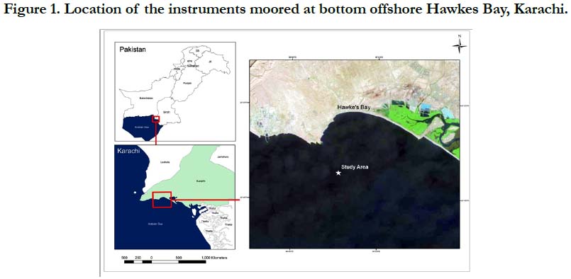
Figure 1. Location of the instruments moored at bottom offshore Hawkes Bay, Karachi.
Material and Methods
In order to record the Tidal Water Levels, RBR Canada manufactured Tide and Wave Recorder TWR -2050 was used to moor along with upward looking Flow Quest 600 Acoustic Doppler Current Profiler (ADCP) at 24°49.1′ N and 066°50.2′ E at a depth of 6.0 m from Chart Datum on 1st May 2010 for one month (Figure 1). Tide recorder and ADCP were programmed and synchronized to record the local time hourly data by using instrument’s software. Flow Quest 600 ADCP has the capability to record current profile from sea surface to the blanking distance of the instrument. To delineate the weather effect, hourly wind condition synchronized with other instruments was recorded with ELE’s CUMULUS Automatic Weather Station that was installed on shore. Although data was recorded using Pakistan Standard time (GMT+5), however to perform the tidal current and water level analysis, data was converted to GMT. Matlab and ESRI ArcGIS software are used for the computation of tidal constituents, calculation of residual levels by using [4] codes and constituent ellipse with sense of rotations were drawn using Martin written codes. The form Factor was computed using [5] as under;
Eq (1)
The ADCP recorded the current data as direction of water movement with reference to North and speed that was converted to Cartesian coordinates “u” (East component) and “v” (North component, and subjected to separate harmonic analyses by applying least square fitting:
Eq (2)
using the tidal current analysis programme written by Godin [6] and later revised by Foreman [7] and coded on Matlab by Codiga [4]. The unknown parameters determined by the analysis in the above equations are the mean current components Uo and Vo and two sets of harmonic constituent amplitudes and phases (Uo, gun) and (Vo, gvn). These four resultant parameters obtained from harmonic analysis are used to define an ellipse which is traced by the tip of the current vector during one complete cycle.
The tidal ellipses mentioned by semi major axis of a tidal constituent gives maximum current velocity and semi minor axis of a tidal constituent gives minimum current velocity within one period for the tidal constituent.
The study area selected to understand the circulation pattern is located in Karachi, west of Karachi Port and east of Cape Monze locally known as RasMuary (Figure 1). Karachi, the coastal city of Pakistan, is located at the extreme western end of the river Indus created Indus delta, and has been turned from mare a small fishing village about 200 years ago to a mega metropolitan city. The city largely comprised of flat or rolling plains, with hills on the western and northern boundaries. The coast line of Karachi is about 70 km long and is generally oriented NW - SE. In the west, it is bounded by the Hub River on the western foot hill of Kirthar range, and in the east by the mangrove swamps and creeks of Indus Delta. Its unique location with a combination of fluvial deposits from Indus river to Pleistocene period Kirther range made most of the Karachi coastal configuration very peculiar [8].
The coast line of Karachi is generally sandy with some rocky features like Cape Monzeat the Northwestern end. Towards the west, steeper slopes become usual, and near the shore region, becomes broken by irregular rocky formations associated with the geological changes observed on land between the deltaic region and the mountains running down to Cape Monze [8] and [9].
The seabed is extremely rugged and apparently composed of rocky strata in the shape of parallel to sub-parallel ridges and valleys diagonal to the coastline. The under water depths are erratic and irregular with little or no predictable trend (Figure 2).
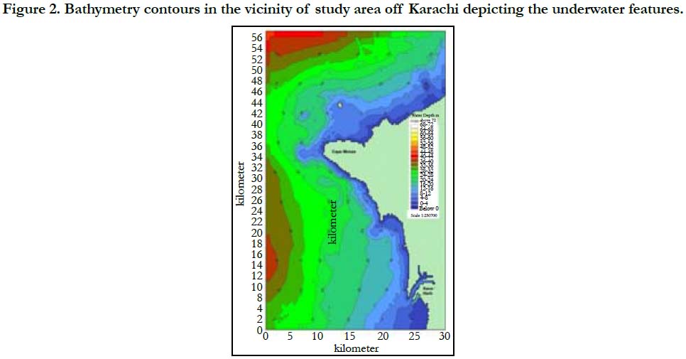
Figure 2. Bathymetry contours in the vicinity of study area off Karachi depicting the underwater features.
The wind recorded at the coast, near the site of current observation during the months of April-June is shown as the wind rose (Figure 3). The data plotted indicates the strong monsoonal forcing. It is general trend along the cost of Pakistan that during the summer monsoon (May-August), the dominant wind direction is either Southwest or South (from sea to land), whereas, during winter monsoon (December-February), there is weak wind blowing from North and Northeast (from land to sea). Southwest winds drag the sea surface to generate the wave that reach the coast with high energy.
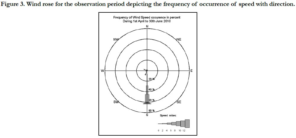
Figure 3. Wind rose for the observation period depicting the frequency of occurrence of speed with direction.
The water levels recorded at the site indicates the similar tidal behavior as in the data being recorded at Karachi Tidal Observatory located within the Karachi Port. The amplitude and Phase of the major tidal constituents, having amplitude more than 1 cm for the recorded site are given in Table 1. The tidal height reconstructed by using computed constituents for the same period is shown in figure 4 with time series observed data, reconstructed levels and residual levels after subtracting the tidal levels from observed data respectively.
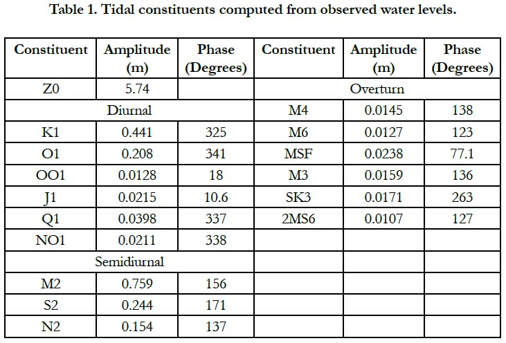

Table 1. Tidal constituents computed from observed water levels.
The form factor as suggested by [5] was determined as 0.65 that is characterized by Pugh as mixed with semidiurnal influence. This behavior of tide is very much depicted in the time series plot in figure 4.
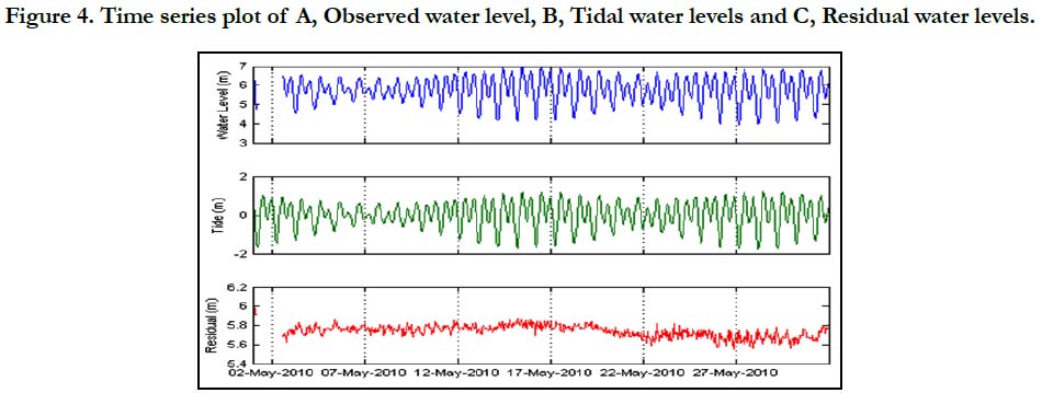
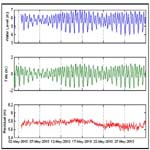
Figure 4. Time series plot of A, Observed water level, B, Tidal water levels and C, Residual water levels.
The recorded data of sea water current for the near surface, 0.6 depth and near bottom was decomposed into east and north to perform the harmonic analysis and computation of tidal constituents. The decomposed observed data is shown as scatter plot in figure 5 while, temporal plot along with predicted current for near surface, 0.6 depth from surface and near bottom separately in figures 6a - 6c. The computed tidal current constituents for the three depths are shown in Table 2.
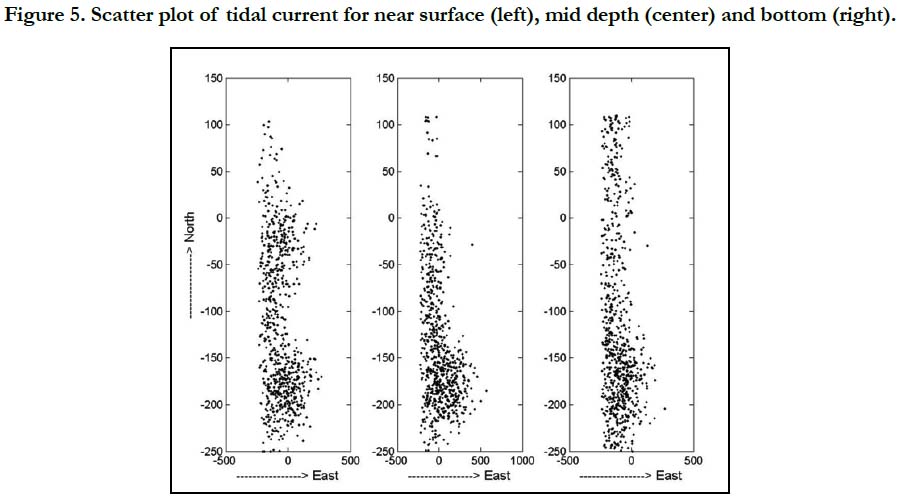
Figure 5. Scatter plot of tidal current for near surface (left), mid depth (center) and bottom (right).
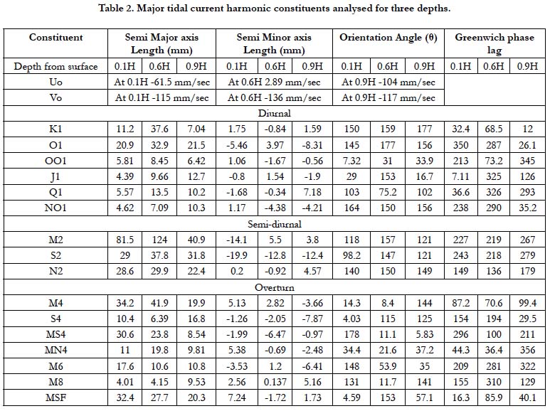
Table 2. Major tidal current harmonic constituents analysed for three depths.
Discussion
Geomorphologically, significant structural movements have occurred along the Karachi coast within the historic time. A broad upwarping of the coast from the Iran border to the Rann of Cutch east of Indus Delta, continues to take place. According to Snead [10] the amount of uplift and tilting varies, uplift lessens toward the east and may be measured in few meters in the Karachi area. The coast, west of Karachi harbour is dominated by spectacular variable and extent, marine terraces with wave-cut platforms elevated above the present mean sea level either due to the land rise or lowering of the sea about 30,000 yr BP [9]. Snead further elaborates that the area between Hawks Bay to Cape Monze, west to the study area, has 12-15m high terraces that further drops to 6-9 m near the study area with 3°E (seaward) dipping bedrock beds. Small caves and a sea arch that has recently been broken and fallen down are developed by storm waves [9].
Similar to topographic features on land underwater bathymetry of the Karachi coastal area depicts the same features. The bathymetric Chart prepared by Pakistan Navy of the study site indicates significant topographic features [11]. The seabed is extremely rugged and apparently composed of rocky strata in the shape of parallel to sub-parallel ridges and valleys diagonal to the coastline. The under water depths are erratic and irregular with little or no predictable trend (Figure 2).
The impact of underwater bathymetry on the sea water circulation is very prominent in the data collected from coastal area of Karachi. The analysis of recorded and plotted data indicate that the seawater currents along Karachi coast are mostly tide dominant, however, wind forcing also plays its role in driving the coastal currents. This phenomenon is clearly depicted in figures 6a - 6c that show the wind generated currents have larger magnitude. The influence of the wind, as wind rose (Figure 3) depict that during recording period it is coming from southwest and south, modifies the tide-driven currents, forcing them to move easterly (Figure 5). Although during summer monsoon, wind generated currents do shape the coastal configuration, but the tidal ebbing and flooding govern mass transport throughout the year. The comparison of observed and predicted currents for the same period show that the wind effect is conveyed up to bottom due to shallow depth and strong monsoonal winds (Figures 6a – 6c). At flood tide, surface currents appear to be slightly weaker with magnitudes that ranged from 0.1-0.46 m/s (Figures 6a-6c). Reduced magnitude of surface currents is evident as they are deflected and slowed down at coastal boundaries [12].
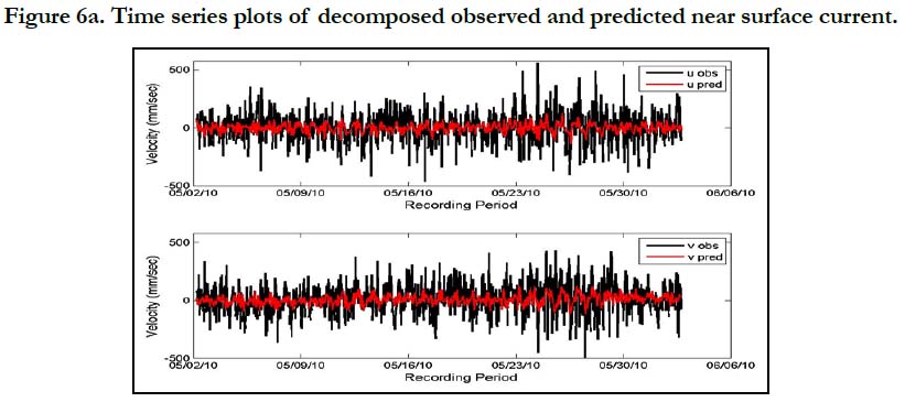
Figure 6a. Time series plots of decomposed observed and predicted near surface current.
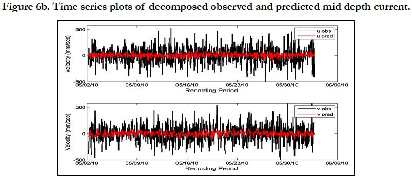
Figure 6b. Time series plots of decomposed observed and predicted mid depth current.
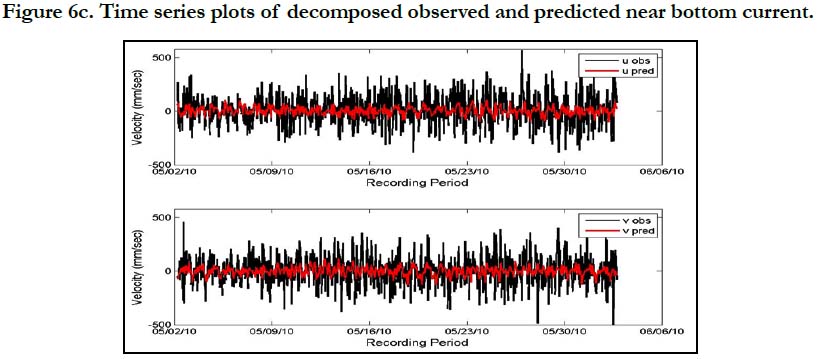
Figure 6c. Time series plots of decomposed observed and predicted near bottom current.
The results of the tidal current analysis are plotted for three depths and major harmonic constituents and shown in figure 7 as constituent ellipses. The tidal current constituents for the three depths are represented through ellipses with the length of semi major and semi minor axis and their phases respectively. Current ellipse parameters such as, semi major axis and semi minor axis are expressed in terms of the magnitudes and phases of the complex amplitudes.
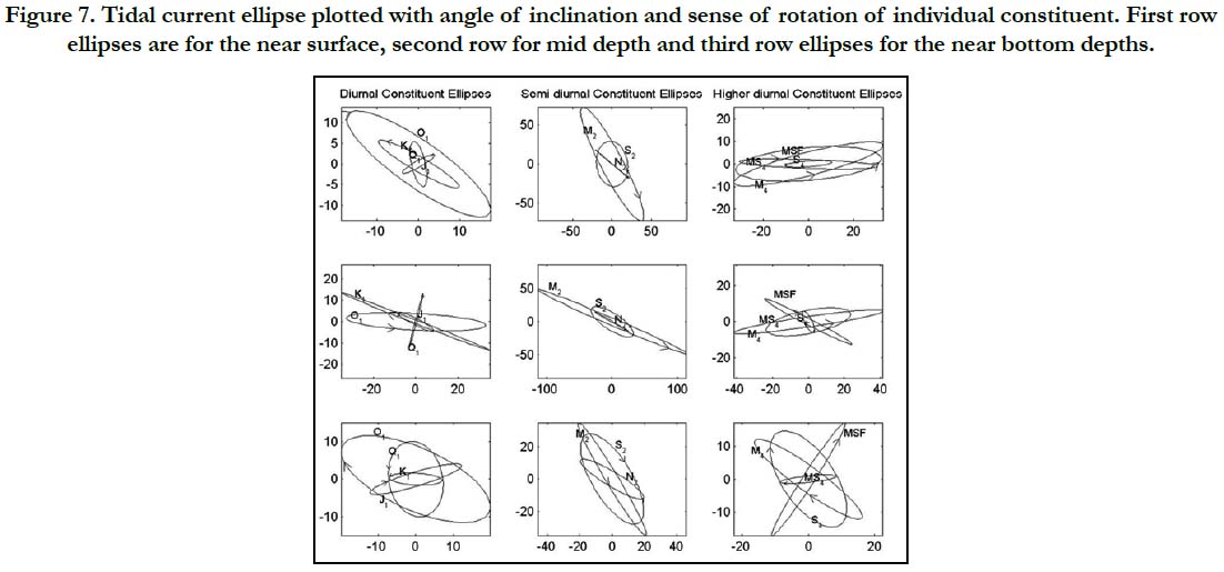
Figure 7. Tidal current ellipse plotted with angle of inclination and sense of rotation of individual constituent. First row ellipses are for the near surface, second row for mid depth and third row ellipses for the near bottom depths.
In the ellipses of every individual constituent, the tip of the velocity vector in the complex plane traces out an ellipse during each full period. The ellipses of diurnal tidal constituents near the surface indicate that there is a steady clockwise rotation of major axis of the ellipses of O1, J1 and Q1 except the K1 that is rotating counterclockwise. However, at the mid depth, K1 & O1 ellipses have opposite sense of rotation to the surface. Whereas, near the bottom, K1 and Q1 have the counterclockwise rotation. The ellipses of semidiurnal constituents M2, S2 and N2 at the surface have the same clockwise rotation, but at the mid-depth M2 has the counterclockwise rotation and near the bottom S2 has the clockwise rotation. Another interesting feature at this location is the clockwise rotation at the bottom for those generated by shallow-water dynamics. The major axis of flow is usually the major axis of the semidiurnal species which is for this site is NWSE that is due to the intrusion of marine terrace in to the sea at the corner of Hawkes Bay. There is another interesting feature, that difference of the phase lags between tidal elevation constituents K1, O1, M2 and S2 and current is varying between 45⁰ -55⁰.
The effects of variations of bottom topography and of coastal configurations on tidal currents have been visible in scatter plot as well as in tidal ellipses and indicate that the tidal currents tend to follow the contours of the near coast bathymetry. The forces which change the directions of current along the coast are predominantly wind and waves.
Conclusion
The least known dynamics of tidal currents along the Pakistani coastal waters is tried to study with the objectives to characterize the variations of the tidal velocity, to ascertain the circulation pattern and impact of underwater topography in training the movement of water along the Karachi coast, in particular, west of Karachi Port.by deploying the ADCP current meterat the location of 24⁰ 49.1′ N and 066⁰ 50.2′ E at a depth of 6.0 m from Chart Datum. The seabed at mooring site is extremely rugged and apparently composed of rocky strata in the shape of parallel to sub-parallel ridges and valleys diagonal to the coastline. The under water depths are erratic and irregular with little or no predictable trend.
The wind condition recorded during the period indicates the dominant wind direction, either Southwest or South (from sea to land), that drag the sea surface to generate the wave towards coast with high energy. The level variationat the site indicates the similar tidal behavior as in the data being recorded at Karachi Tidal Observatory located within the Karachi Port. The seawater currents recorded at the site show that at flood tide, surface currents appear to be slightly weaker with magnitudes that ranged from 0.1-0.46 m/s. Reduced magnitude of surface currents is evident as they are deflected and slowed down at coastal boundaries.
The result of the tidal current analysis revealed that the ellipses of diurnal tidal constituents near the surface rotate clockwise except the K1 that is rotating counterclockwise. However, at the mid depth, K1 & O1 ellipses have opposite sense of rotation to the surface. Near the bottom, K1 and Q1 have the counterclockwise rotation. The ellipses of semidiurnal constituents M2, S2 and N2 at the surface have the same clockwise rotation, but at the middepth M2 has the counterclockwise rotation and near the bottom S2 has the clockwise rotation. The major axis of flow is usually the major axis of the semidiurnal species which is for this site is NW-SE that is due to the intrusion of marine terrace in to the sea at the corner of Hawkes Bay. The result of the study concludes that the effects of variations of bottom topography and of coastal configurations on tidal currents are also visible in scatter plot as well as in tidal ellipses and indicate that the tidal currents tend to follow the contours of the near coast bathymetry. Furthermore, the forces which change the directions of current along the coast are predominantly wind and waves.
Contribution of Authors
Naeem Ahmed Syed planned the study collected the data, performed the analysis and interpreted the results, whereas, Tahira Siddiqa prepared the results in presentable form using mentioned softwares.
Acknowledgement
Authors wishes to acknowledge Dr. Asif Inam Director General National Institute of Oceanography, Karachi for the access of archive data, and Professor Dr. Mirza Naseer Ahmed for providing facilities of GIS and Remote Sensing Laboratory of Department of Earth Sciences, Abdus Salam School of Sciences using ArcGIS and Matlab softwares.
References
- Carbajal N, Gaviño JH. A new theory on tidal currents rotation. Geophysical research letters. 2007 Jan; 34(1).
- Rizvi SH, Ali A, Naeem SA, Tahir M, Baquer J, Saleem M, Tabrez SM. Comparison of the physical properties of seawater offshore the Karachi coast between the northeast and southwest monsoons. In Marine Science of the Arabian Sea. Proceedings of an International Conference, American Institute of Biological Sciences, Washington, DC .1988; 619 - 626.
- Snead RJ. Geography, Geomorphic Process and Effects on Archaeological Sites on the Makran Coast. In Himalaya to the Sea. Routledge. 2002 Sep 26;247-256.
- Codiga DL. Unified tidal analysis and prediction using the UTide Matlab functions. Narragansett, RI: Graduate School of Oceanography, University of Rhode Island; 2011 Sep.
- Pugh DT. Tides, surges and mean sea level. John Wiley & Sons Ltd , Swindon, UK. 1987.
- Godin G. The analysis of tides. Liverpool University Press, Liverpool. 1972.
- Foreman MG. Manual for Tidal Currents Analysis and Prediction, Pacific Marine Science Report 78-6, Institute of Ocean Sciences, Patricia Bay, Sidney. British Columbia. 1978;70.
- Gauhar SH. "Geological Survey Map Series 3". Geological Survey of Pakistan, Karachi, 1963.
- Snead RJ. Uplifted marine terraces along the Makran coast of Pakistan and Iran.1st ed. In Himalaya to the Sea, Routledge, London. 2002 Sep 26; 205- 226.
- Snead RE. Physical geography of the Las Bela coastal plain, West Pakistan. LSU Historical Dissertations and Theses, Graduate School at LSU Digital Commons, Louisiana. 1963;1-213.
- Pak-5. Approaches to Karachi. Hydrographer Pakistan Navy, Karachi, 2003.
- Foreman MG. Manual for Tidal Currents Analysis and Prediction Pacific Marine Science Report 78-6. Institute of Ocean Sciences, Patricia Bay, Sidney, BC. 1978;57.